WALLACE W HANSEN
Native Plants of the Northwest
Native Plant Nursery & Gardens
2158 Bower Ct S.E., Salem, Oregon 97301 E-Mail:
Wallace W Hansen
PHONE (503)581-2638 FAX(503)581-9957

WALLACE W HANSENNative Plants of the NorthwestNative Plant Nursery & Gardens2158 Bower Ct S.E., Salem, Oregon 97301 E-Mail:
Wallace W Hansen |
|
| Information about Wallace W Hansen Northwest Native Plant Nursery & Gardens: Business Information (Ordering, etc.) | |
Updated September 7, 2003 |
Wallace Hansen Celebrates Lewis and Clark's Bicentennial |
|
|
|
|
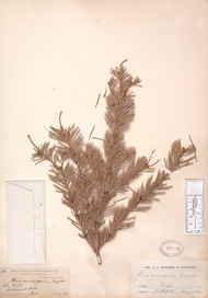
Botanical Discoveries of the Lewis and Clark ExpeditionSubalpine Fir (Abies lasiocarpa)Idaho's Bitterroot Mountains, September 15, 1805A beautiful, small evergreen tree, with delightful forms, this is the most widespread of the Abies genus. Found from the Yukon to New Mexico and west to the Pacific coast, this variety favors high elevations, cold climates and moist sites. Hardy USDA zones 2-9. Trees grow slowly, reaching 80’ at maturity, with a narrow, conical shape and spiky, cathedral-like spires. The 1½” needles are stiffly upturned and blue gray-green in color. Perfect for small gardens and mitigation projects, the Sub-Alpine is a natural pioneer in disturbed areas and prevents erosion. When heavily laden with snow (a common winter occurrence in much of its range) the lowest branches often touch the ground and by spring, will have grown roots! Lewis and Clark specimen is not available, lost during the expedition or in the many moves of the collection afterward. Subalpine Fir is included in our Fall Sale, as well as many other trees and shrubs (and bulbs/rhizomes) that were collected by Lewis and Clark. |
Collected by S. Watson, Lolo Trail Idaho, August 20, 1880 Photo of specimen from Smithsonian National Museum of Natural History |
At this time in 1804:Previously, we have been sampling journals from 1806. We now go back to 1804 to journals from the first year of the expedition, not long after it's beginning. We see a definite change in the tone of the captains when the journey was fresh and hopes were high:
Captain Clark has a full supply of gifts to share with visitors and he seems a bit more discerning in his feelings for these peoples he has not previously met. When the expedition passes this way again in two years' time, he is much more matter-of-fact. |
Current events: |
|
Exhibit: End of Our Voyage Exhibit
August 8- September 25, 2003 Lewis and Clark Bicentennial in Oregon (www.lcbo.net) May 23 - September 15, 2003: The Lewis & Clark Explorer Train Traveling from Portland to Astoria, via the water level Columbia River rail route. Contact: Oregon Department of Transportation, download fact sheet (PDF file).
Field Trip: The Overland Trail and Camp Out September 21-22, 2003
For More Information: |
|
"Down the Great Columbia" Living history at Sacajawea State Park, Pasco, WA October 18, 10 am - 5 pm Programs last approximately 45 minutes. Please bring a folding chair and a flashlight. All programs are open to the public for a $2.00 per person fee which includes parking for the duration of the program. Program parkins is available near the interpretive area at the campground entrance. Call the Park Ranger at 509-337-6457 for additional information. Programs may be cancelled due to inclement weather. |
|
|
|
End
of the Oregon Trail Interpretive Center
Location: 1726 Washington Street, Oregon City, OR 97045 (503) 657-9336 (503) 557-8590 End of the Oregon Trail Interpretive Center Website staff@endoftheoregontrail.org Description: The End of the Oregon Trail Interpretive Center was built in 1995 on the former Donation Land Claim of the first elected governor of the Oregon Country, George Abernethy. A merchant and miller by trade, Abernethy had a vested interest in the continued growth of Oregon City, so he permitted newly arrived emigrants to park their wagons, graze their oxen, and set up camp on a meadow behind his house. That meadow came to be called Abernethy Green, and for many of the early Oregon Trail emigrants, it truly was the Trail's end. |
|
Directions
and/or Additional Information: The End the Oregon Trail Interpretive
Center is easy to find, as the geology and patterns of settlement within
the Willamette Valley have dictated the routes of major roads from Indian
footpaths to modern highways. The simplest way to reach the Interpretive
Center is to take Interstate 205 to Exit 10, which is signed for Park
Place, Molalla, and State Route 213, the Trail's End Highway. Once off the
Interstate, turn right at the first stoplight. The Interpretive Center is
about half a mile down the road. You literally can't miss "the Big
Wagons" on your left at 1726 Washington Street.
Alternative approaches are via State Routes 213, 99-E, and 43. The Interpretive Center is just off the end of SR 213 -- turn left at the last light before the Interstate. Taking 99-E or 43 gives you the option of cutting over to Washington Street on the surface streets if you're familiar with Oregon City, but it's easier to take northbound I-205 to Exit 10 from both roads. Here's a handy tip for those arriving on 99-E: the entrance ramp from 99-E is a continuous lane that becomes the exit ramp for SR 213, so you are spared from having to merge with the through traffic on the Interstate. |
|
|
Back Issues:To see back issues of Wallace Hansen Celebrates Lewis and Clark, click on this link to jump to the index. |
Commemorative Painting by Heidi Hansen:The illustrated map below was created by renowned botanical artist Heidi D. Hansen especially for this website. Done in ink and watercolors, Heidi shows many of the plants Captain Lewis documented overlaid atop a map showing a portion of the journey. (Click on image for large view). All the plants pictured are available from Wally Hansen! See our Spring Sale site and our online catalog for more information. |
|
|
|
|
|
|
|
|
|
Click here to return to my Home Page |
|
Questions about plants, click here: Regular Email to Wally To order, click here: Secure Email to Wally |
|
|
Comments or questions about our web site, click here: Webmaster |