WALLACE W HANSEN
Native Plants of the Northwest
Native Plant Nursery & Gardens
2158 Bower Ct S.E., Salem, Oregon 97301 E-Mail:
Wallace W Hansen
PHONE (503)581-2638 FAX(503)581-9957

WALLACE W HANSENNative Plants of the NorthwestNative Plant Nursery & Gardens2158 Bower Ct S.E., Salem, Oregon 97301 E-Mail:
Wallace W Hansen |
|
| Information about Wallace W Hansen Northwest Native Plant Nursery & Gardens: Business Information (Ordering, etc.) | |
Updated June 28, 2003 |
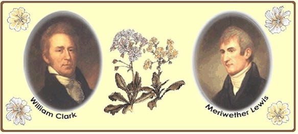
Wallace Hansen Celebrates Lewis and Clark's Bicentennial |
|
|
|
|
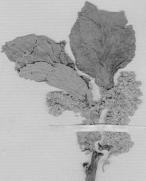
Botanical Discoveries of the Lewis and Clark ExpeditionBuckbrush or Chaparral (Ceanothus sanguineus)Collected on June 27, 1806 along Idaho's Lolo Trail A favorite food of deer, hence the name "Buckbrush." Early settlers, coming years after the expedition, called this plant "soapbloom" because the flowering twigs produced a soapy foam when beaten in water. This occurs because the plant contains the toxin saponin, in modern times used for soaps and shampoos. Related to our BlueBlossom, this shrub was labeled "Ceanothus atropurpureus" by Pursh. Notes on the label state that Lewis found "a large speceis of redroot now in blume" (Moulton, 1993: 7) on 10 Jun 1806 which is certainly this species. Apparently a specimen was not gathered until the party was traveling on 27 Jun near Hungery Creek along the Lolo Trail in Idaho Co., Idaho (Moulton, 1993: 55-59). The expedition traveled some 28 miles that day. It is possible the date "Jun. 27, 1806." on the sheet is incorrect. If so, the specimen probably was collected at Camp Chopunnish near Kamiah in Idaho Co., Idaho. Pursh: "Ceanothus atropurpureus. Near the foot of the Rocky mountain, on Collins Creek. Jun. 27, 1806." Lambert: "Herb: Lewis & Clarck." It's a good time to plant this Northwest Native shrub, available now at our low Spring Sale prices. See this and many other shrubs, trees, and perennials at the nursery and gardens now. |
Buckbrush, Chaparral (Ceanothus sanguineus)
Click on pictures for large views |
At this time in 1806:The guides have joined the Expedition and it's time to move on. The "Indians" (Native Peoples) give the Corps a show as a special treat:
Hmmm, bear's oil and boiled roots. Captain Clark calls this an "agreeable dish." It would, at least, be nourishing and probably tasted just fine out in the wild country surrounded by snow-capped mountains. Note the wild ginger poultice used to ease the inflamation of Joe Pott's leg. Good medicine. |
Current events: |
|
|
Create
an Event
The Department of Interior has released their Lewis and Clark Bicentennial Funding Sourcebook. This document has been compiled to assist States, Tribes, and communities in locating potential, existing sources of Federal, State, and philanthropic support for Bicentennial projects. See this website for more information: http://www.lewisandclark200.org/news/currentnews.html |
|
|
|
|
|
Discover
Travelers' Rest Traveler's Rest State Park is just south of Lolo Creek, 1/4 mile west of Highway 93, at 6550 Morman Creek Road in Lolo. June
30, 2003 - July 3, 2003
|
|
|
|
|
|
Lunch
with Lewis Lunch With Lewis will take place at Nine Mile Prairie in Geenough, MT. Follow Rt. 200 (Bonner exit off I-90, 7 miles east of Missoula, MT) to milepost 26.5, turn west onto Nine Mile Prairie Rd. and follow 'Lunch With Lewis' signs for for 6.5 miles. It's 1/2 mile past Corrick River Bend Campground. A map to the event can be found at http://www.mapquest.com/maps/map.adp?email=1&mapdat July
5, 2003 (11am-4pm)
|
|
|
|
|
|
End
of the Oregon Trail Interpretive Center
Location: 1726 Washington Street, Oregon City, OR 97045 (503) 657-9336 (503) 557-8590 End of the Oregon Trail Interpretive Center Website staff@endoftheoregontrail.org Description: The End of the Oregon Trail Interpretive Center was built in 1995 on the former Donation Land Claim of the first elected governor of the Oregon Country, George Abernethy. A merchant and miller by trade, Abernethy had a vested interest in the continued growth of Oregon City, so he permitted newly arrived emigrants to park their wagons, graze their oxen, and set up camp on a meadow behind his house. That meadow came to be called Abernethy Green, and for many of the early Oregon Trail emigrants, it truly was the Trail's end. |
|
|
Directions
and/or Additional Information: The End the Oregon Trail Interpretive
Center is easy to find, as the geology and patterns of settlement within
the Willamette Valley have dictated the routes of major roads from Indian
footpaths to modern highways. The simplest way to reach the Interpretive
Center is to take Interstate 205 to Exit 10, which is signed for Park
Place, Molalla, and State Route 213, the Trail's End Highway. Once off the
Interstate, turn right at the first stoplight. The Interpretive Center is
about half a mile down the road. You literally can't miss "the Big
Wagons" on your left at 1726 Washington Street.
Alternative approaches are via State Routes 213, 99-E, and 43. The Interpretive Center is just off the end of SR 213 -- turn left at the last light before the Interstate. Taking 99-E or 43 gives you the option of cutting over to Washington Street on the surface streets if you're familiar with Oregon City, but it's easier to take northbound I-205 to Exit 10 from both roads. Here's a handy tip for those arriving on 99-E: the entrance ramp from 99-E is a continuous lane that becomes the exit ramp for SR 213, so you are spared from having to merge with the through traffic on the Interstate. |
|
|
|
|
Back Issues:To see back issues of Wallace Hansen Celebrates Lewis and Clark, click on this link to jump to the index. |
|
Commemorative Painting by Heidi Hansen:The illustrated map below was created by renowned botanical artist Heidi D. Hansen especially for this website. Done in ink and watercolors, Heidi shows many of the plants Captain Lewis documented overlaid atop a map showing a portion of the journey. (Click on image for large view). All the plants pictured are available from Wally Hansen! See our Spring Sale site and our online catalog for more information. |
|
|
|
|
|
|
|
|
|
|
|
|
|
|
Click here to return to my Home Page |
|
Questions about plants, click here: Regular Email to Wally To order, click here: Secure Email to Wally |
|
|
Comments or questions about our web site, click here: Webmaster |